GBA_Main_Report.pdf
Download PDF [6 MB]
(Revised Post 11th August 2026)
Guildford Borough Council are starting to publish documents that contribute to the Evidence Base (See linked post at the foot of this post) that will be considered during the development of the new Local Plan in 2029.
The document that will produce the most comment is the Green Belt Assessment (GBA) that shows most of the Green Belt in Guildford borough is now classed as "grey belt" or "potentially grey belt" having been assessed using the planning rules embodied in the National Planning Policy Framework adopted in 2024. Grey Belt designation lowers protection against development substantially compared to Green Belt.
Grey Belt was introduced with the adoption of the NPPF (2024) (See NPPF at foot of this post). The designation lowers protection against development substantially compared to Green Belt.
The legal status of the Green Belt Assessment (GBA) is explained on the linked post Evidence Base at foot of this post and it is also subject to revision due to the the NPPF (2026) which has been put into effect from 16th August 2026 This will cause the GBA to be re-issued in the autumn.
The NPPF (2024) guides planning and contains the policies defining Green Belt and Grey Belt. It can be used to propose that areas of Green Belt land should be considered as Grey Belt, which is a sub category of Green Belt, and that development should be allowed, provided other planning rules are followed. Guildford has several sites proposed where developers are arguing that a site should be considered as Grey Belt sites. This could lead to a series of Ad Hoc Developments eroding the existing Green Belt.
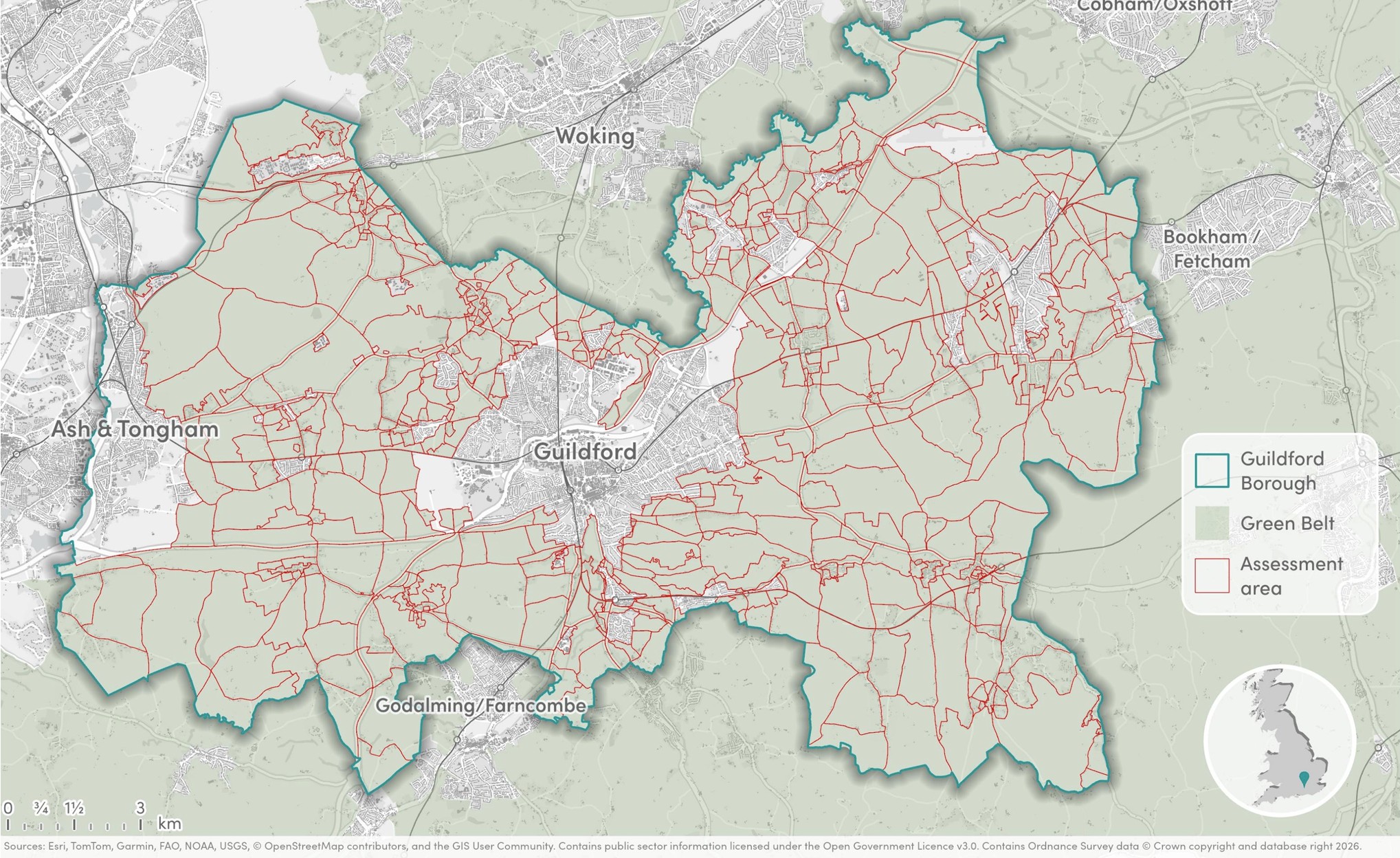
The red lines on the map show the assessment areas.
Guildford Green Belt Assessment
Green Belt serves five purposes as set out in the current NPPF 2024 at Para 143.
a) to check the unrestricted sprawl of large built-up areas;
b) to prevent neighbouring towns merging into one another;
c) to assist in safeguarding the countryside from encroachment;
d) to preserve the setting and special character of historic towns;
e) to assist in urban regeneration, by encouraging the recycling of derelict and other urban land.
The NPPF 2024 also introduced a designation of 'grey belt' that is Greenbelt land that does not strongly contribute to any of the following three Green Belt purposes as set out above, these are:
a) to check the unrestricted sprawl of large built-up areas;
b) to prevent neighbouring towns merging into one another
d) to preserve the setting and special character of historic towns.
Grey Belt status is very important as it substantially reduces the protections afforded by Green Belt status, and as can be seen covers substantial areas not just the odd old car park/petrol station as implied in Government announcements.
GBC have used an independent consultancy (AECOM) to assess what the rules mean for every part of Guildford's greenbelt - producing a report the report is attached to post below or can be accessed at GBC Website at Green Belt Assessment (GBA).
It is important to note that a GBA has no Legal Status and thus doesn't change Green Belt boundaries, which only change as part of the Local Planning process, or as part of individual development applications as referenced above. See paragraph on Legal Weight of Assessment Documents at foot of the post. The assessment is only evidence to justify boundary changes.
How the Assessment relates to the new Guildford Local Plan?
The GBA does not make any decisions on what land will be allocated for development in the Local Plan. National policy states that Local Plans are expected to meet the identified need in full. If sufficient land cannot be allocated from exisiting sources to meet the assessed need the NPPF states that this can constitute the exceptional circumstances necessary to justify altering Green Belt boundaries. When altering Green Belt boundaries plans should give priority to previously developed land, then consider Grey Belt which is not previously developed, and then other Green Belt locations. However, this must be in the context of promoting a sustainable pattern of development. For this reason, it may in some instances be preferable to allocate non grey belt land over grey belt land.
The GBA uses as its basis the NPPF published in 2024 (NPPF 2024) .
GBA excludes land in certain areas where national planning policy related to Para 11 - The presumption in favour of sustainable development (called NPPF ‘Footnote 7’ constraints) provides a strong reason for refusing or restricting development. This highlights constraints on the use of land relating too:
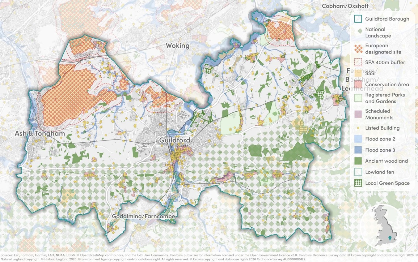
The GBA thus also assesses land against Footnote 7 that are applicable in the borough before determining whether land can be considered grey belt.
The use of Footnote 7 has caused a large area of Green Belt to be considered as 'provisionally Grey Belt). Considering that a large area of Provisionally Grey Belt is covered by Surrey Hills National Landscape, Ancient woodland etc it is very concerning that the NPPF policies allow these sites to be considered.
Note there is an important caveat see 'Revised Methodology' below.
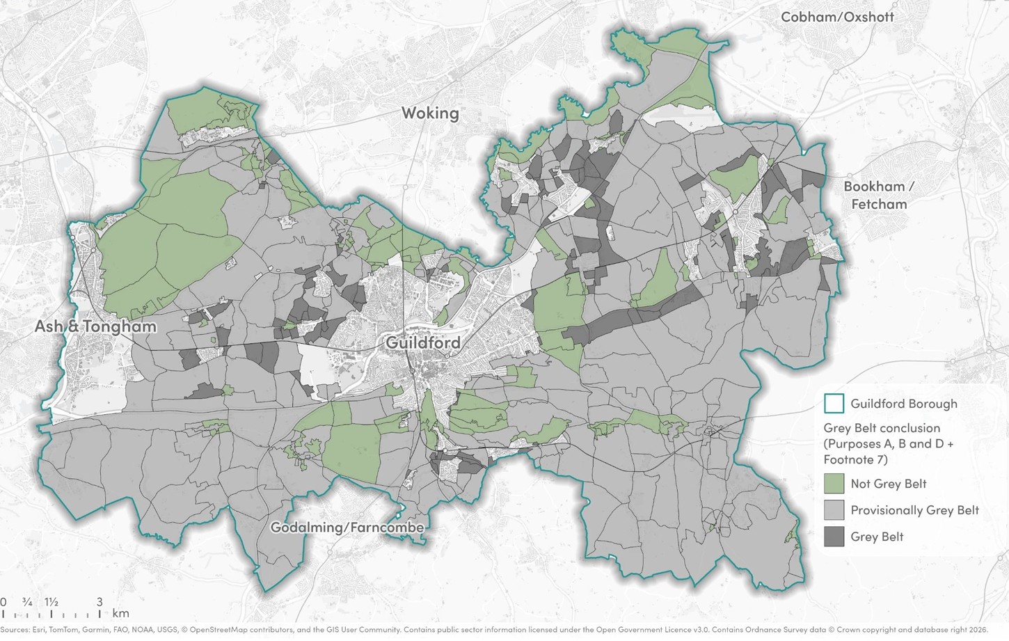
Once designated as grey belt' developers still need to prove that that the proposed development meets three golden rules
Identifying land as grey belt does not grant planning permission. The GBA is an evidence base and will be a starting point only for decision taking regarding sites that may be grey belt. The decision maker (planning officers, planning committee or a planning inspector) will still need to consider the site-specific circumstances and make their own assessment regarding whether the site is grey belt or not. However the Assessment Document informs this debate.
The full report has been published online on the council website together with accompaning detailed maps has been published on the GBC Web Site See this Link. The report and a useful FAQ paper produced by the council are also appended to the foot of this post.
The Assessment will be RE-ISSUED in the autumn (Source GBC FAQ’s on the GBA See Document at Foot of Post) to reflect the changes arising from the new NPPF(2026) - See draft at foot of this post - due to be made operational in the Autumn.
The Council's FAQ's state
Question 16. Is the grey belt definition expected to change? Yes. A new version of the NPPF was consulted upon earlier this year. This proposed to remove the Footnote 7 constraint element of the definition. This change has yet to be confirmed. We expect the final version of the NPPF to be published in the Autumn.
Question 17. What will happen if the definition changes? If the definition is amended as proposed in the consultation version of the NPPF the GBA will be re-issued without the Footnote 7 component. This would mean there would no longer be a ‘provisionally grey belt’ category and all Green Belt would either be grey belt or not grey belt.
Footnote 7 Considerations will no longer be relevant. The policies that appear relevant in the Draft NPPF (2026) appear to be Policy 13. Protecting Green Belt landand Appendix E. GBC believe this will cause a revision of the map to reflect the the removal of the ‘provisionally Grey Belt’ category. A baseline map for this is shown below showing assessment against overall purposes A,B,C,and D.
It must be expected more Grey Belt sites will be added to this. The NPPF (2026). for example, also promotes removal of Green Belt Status around transport hubs and allows for denser forms of development.
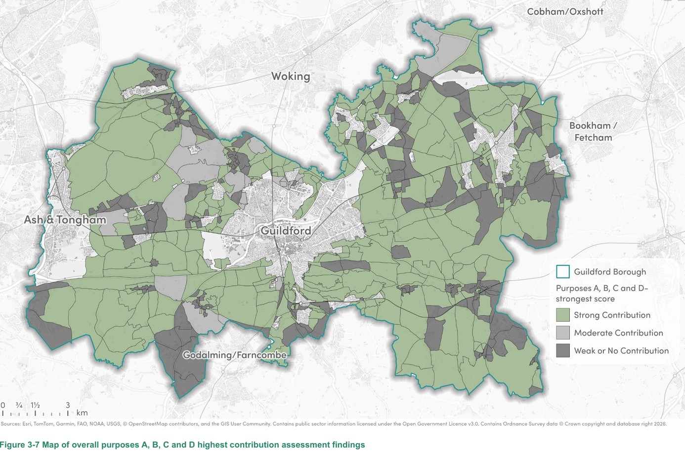
The draft NPPF (2026) has Policy S1 Positive Plan Making that makes reference to applying policies within the NPPF 2026 to plan making that are at Footnote 23 these relate to: habitats sites and/or designated as Sites of Special Scientific Interest; land designated as Green Belt, Local Green Space, a National Landscape, a National Park (or within the Broads Authority) or defined as Heritage Coast; irreplaceable habitats; designated heritage assets; and areas at risk of flooding or coastal change.
The NPPF (2026) has been put into effect as from the 16th August 2026 - THERE COULD STILL BE SURPRISES TO COME once this has been aligned to the GBA.
The NPPF (2026) is attached to the foot of this post.
The Society is very concerned how the GBA will evolve.
The findings of the assessment are very concerning. Guildford is at risk as it must deliver more housing (circa 1100 per annum double the previous delivery rate) to meet a central government edict.
The Green Belt Assessment creates an open season for developers over a wide swathe of land in the borough as, although it doesn't legally, change boundaries it provides rationale for developers to ask to individual areas to be redeveloped. Guildford won’t have an updated local plan until q1 2029 and we are in danger of a developer free-for-all that results in piecemeal developments being built lacking a sense of place, infrastructure and social facilities.
Campaign to Protect Rural England (CPRE) Hertfordshire and London Green Belt Council have produced timely report on the impact of Grey Belt.
View article Evidence Base - Local Plan 2029 View articleEvidence Base is being assembled to support Local Plan Development for 2029 plan
View articleHelp us make Guildford better
We want our town to be vibrant, attractive and liveable. We support development that brings a sense of place and enhances the best aspects of our town. If such aims can be embraced, we believe Guildford has the chance to lead the way in enabling sensitive and sustainable development.
Pressures for development are increasing. Planning rules are being eased. The Society’s commitment to standing up for Guildford is needed more than ever.
Support Us
Getting involved allows the society to continue its work. We welcome new members, from every age and background. Membership provides an opportunity for you to contribute to the continued health of the town and surrounding area, and to meet other people who care about Guildford.